The Sundarbans, a name that whispers of beauty and untamed wilderness, is a sprawling emerald tapestry woven across the delta of the Ganges, Brahmaputra, and Meghna rivers. More than just a forest, the Sundarbans is a dynamic, breathing ecosystem – the largest mangrove forest on Earth – a labyrinth of tidal waterways, mudflats, and islands straddling the border of India and Bangladesh. This extraordinary realm, a UNESCO World Heritage Site, pulsates with life, harboring iconic species like the Royal Bengal Tiger, alongside a breathtaking array of flora and fauna uniquely adapted to its brackish embrace. Yet, this precious jewel is under threat, facing the relentless pressures of climate change and human encroachment, making its exploration and understanding more vital than ever.
Introduction to the Sundarbans: Where Rivers Meet the Sea
The very essence of the Sundarbans lies in its geography, born from the confluence of mighty rivers rushing to meet the Bay of Bengal. This deltaic formation, sculpted over millennia, is a living testament to the power of nature’s artistry. The name “Sundarbans,” literally translating to “beautiful forest” in Bengali, hints at the visual splendor that awaits within its verdant depths. However, some scholars suggest a derivation from “Sundari,” the local name for Heritiera fomes, the dominant mangrove species, further emphasizing the forest’s defining botanical character. Irrespective of its etymological roots, the name perfectly encapsulates the captivating beauty and ecological significance of this unique region.
Geographical Location and Formation: A Deltaic Marvel
Imagine a landscape where land and water constantly intertwine, where the rhythm of tides dictates life’s tempo. This is the geographical reality of the Sundarbans. Located in the vast Ganges Delta, it stretches from the Baleswar River in Bangladesh to the Hooghly River in India, encompassing parts of the Khulna Division of Bangladesh and the state of West Bengal in India. The forest’s formation is an ongoing process, driven by the immense sediment load carried by the Ganges, Brahmaputra, and Meghna rivers. As these rivers meet the sea, the sediment deposits, creating new landmasses and shaping the intricate network of islands and waterways that characterize the Sundarbans. This constant flux, the interplay of freshwater and saltwater, creates the perfect environment for mangrove forests to flourish.
The total area of the Sundarbans spans approximately 10,277 square kilometers (3,968 sq mi). A larger portion, around 6,017 sq km (2,323 sq mi), falls within Bangladesh, while the Indian part covers about 4,260 sq km (1,640 sq mi). Within this expanse, forests – both closed and open mangrove types – share space with agricultural lands, mudflats, barren patches, and a dense web of tidal streams and channels, creating a mosaic of habitats that support a remarkable diversity of life.
Defining the Sundarbans: More Than Just Mangroves
While mangroves are undoubtedly the defining feature of the Sundarbans, it is crucial to understand that this ecosystem is far more complex than just a mangrove forest. It is a dynamic intertidal zone, a transitional realm where terrestrial and marine ecosystems converge. The Sundarbans is a complex ecological tapestry encompassing:
- Mangrove Forests: These are the heart of the ecosystem, composed of salt-tolerant trees and shrubs that thrive in the intertidal zones. They form dense canopies, intricate root systems that stabilize the coastline, and provide vital habitat for countless species.
- Freshwater Swamp Forests: Located inland from the mangroves, these areas experience less salinity, particularly during the rainy season. They represent a transition zone between the mangrove ecosystem and the inland forests.
- Mudflats: Vast expanses of silt and clay exposed during low tide, teeming with invertebrates and providing feeding grounds for birds and fish.
- Waterways: A labyrinth of rivers, creeks, and canals, forming the arteries of the Sundarbans, facilitating nutrient flow, transportation, and connecting different parts of the ecosystem.
- Islands and Sandbars: Small islands and shifting sandbars, often colonized by pioneering vegetation, adding to the dynamic and ever-changing landscape.
This intricate interplay of different habitats is what makes the Sundarbans such a biodiversity hotspot and a critical ecological buffer for the densely populated regions it borders.
A Journey Through History: Echoes of Civilizations
The history of human interaction with the Sundarbans stretches back millennia, weaving a rich tapestry of settlements, legends, and resource utilization. From ancient times to the modern era, humans have been drawn to this unique environment, leaving their imprint while also being shaped by its forces.
Ancient Roots and Mythological Connections
Archaeological evidence suggests human presence in the Sundarbans region as far back as the Mauryan era (4th-2nd century BCE). The discovery of an abandoned city ruin within the Baghmara Forest Block is linked to Chand Sadagar, a pre-Mauryan figure prominent in Bengali folklore. This semi-historical merchant is often associated with riverine trade and prosperity, suggesting the Sundarbans may have been a significant trading hub even in ancient times. Further archaeological excavations at Kapilmuni, north of the Sundarbans, have unearthed urban settlement ruins dating back to the early Middle Ages, indicating continued human activity and development in the region. These findings paint a picture of a historically significant landscape, intertwined with local myths and legends.
Mughal Era and the British East India Company
During the Mughal period, local rulers leased out tracts of the Sundarbans forests for settlement. This marks a shift towards more formalized resource management and land use. However, a pivotal moment arrived in 1757 when the British East India Company gained proprietary rights over the Sundarbans from the Mughal Emperor Alamgir II. The British recognized the strategic and economic value of the region, commissioning the first mapping of the area in 1764. This marked the beginning of systematic exploration and exploitation of the Sundarbans by colonial powers, setting the stage for future forest management and administration.
Establishing Forest Management: A Century of Evolution
While the British mapped the Sundarbans in the 18th century, organized forest management began a century later. The first Forest Management Division with jurisdiction over the Sundarbans was established in 1869. A significant step towards conservation came in 1875 when a large portion of the mangrove forests was declared as reserved forests under the Indian Forest Act of 1865. The remaining forest areas were similarly declared reserved the following year. This marked a transition from civil administration to dedicated forest management under the Forest Department. In 1879, a Forest Division was created, headquartered in present-day Khulna, Bangladesh, signifying the growing administrative and conservation focus on the Sundarbans. The first formal management plan for the forest was written for the period 1893-1898, laying the foundation for sustainable resource utilization and conservation practices that continue to evolve today.
Geography and Physiography: The Labyrinthine Landscape
The geography of the Sundarbans is its defining characteristic, a mesmerizing labyrinth of interconnected waterways and islands. Understanding its physiography is key to appreciating its unique ecology and the challenges it faces.
The Deltaic Formation and River Systems: A Network of Life
The Sundarbans sits at the heart of the Ganges River Delta, the largest delta in the world. This delta is formed by the confluence of the Hooghly, Padma (both distributaries of the Ganges), Brahmaputra, and Meghna rivers as they converge before emptying into the Bay of Bengal. The seasonal flooding is a critical aspect of the Sundarbans ecosystem. During monsoon season, the freshwater swamp forests inland become inundated, while the mangrove forests closer to the coast experience tidal flooding daily. This dynamic interplay of freshwater and saltwater, coupled with the sediment-rich waters, shapes the unique soil composition and vegetation patterns of the Sundarbans.
The rivers within the Sundarbans are not just waterways; they are lifelines. They carry nutrients, disperse seeds, support fisheries, and facilitate the movement of wildlife and people. The major river systems include:
- Hooghly River (India): Marks the western boundary of the Sundarbans in India.
- Padma River (Bangladesh): A major distributary of the Ganges, flowing through the heart of the Sundarbans in Bangladesh.
- Baleswar River (Bangladesh): Forms the eastern boundary of the Sundarbans.
- Meghna River: Contributes to the deltaic formation, though its main channel lies east of the Sundarbans.
Countless smaller rivers, creeks, and canals branch out from these main arteries, creating the intricate network that is both a defining feature and a navigational challenge of the Sundarbans.
Interconnected Waterways and Accessibility: A Boatman’s Paradise
The interconnected network of waterways is so extensive in the Sundarbans that almost every corner of the forest is accessible by boat. This has historically shaped transportation, resource extraction, and even the way of life in the region. Boats are not merely a mode of transport; they are essential for livelihoods, connecting communities, and facilitating tourism. From small fishing boats to larger ferries and tourist vessels, the waterways are constantly active, buzzing with life and movement. This unique accessibility by water is a major draw for eco-tourism, offering visitors an unparalleled opportunity to explore the hidden depths of the mangrove forests.
Soil Composition and Land Morphology: Shaped by Tides and Sediments
The soil of the Sundarbans is primarily deltaic, formed from the deposition of sediments carried by the rivers. It’s a mixture of silt and clay, rich in organic matter, and constantly being reshaped by tidal action and river flows. The land morphology is characterized by:
- Deltaic Plains: Flat, low-lying plains created by riverine deposition.
- Tidal Flats: Areas exposed at low tide and submerged at high tide, crucial for mangrove colonization and invertebrate life.
- Levees: Natural embankments along riverbanks, formed by sediment deposition during floods.
- Splays: Fan-shaped deposits of sediment that spread out from breaches in levees.
- Marginal Marshes: Areas above the mean tide level, often characterized by specific vegetation adapted to slightly less saline conditions.
- Tidal Sandbars and Islands: Shifting and dynamic landforms, constantly being created and eroded by tidal currents.
The land elevation in the Sundarbans is very low, ranging from just 0.9 to 2.11 meters (3.0 to 6.9 ft) above sea level. This low elevation makes the region particularly vulnerable to sea-level rise and storm surges, highlighting the critical protective role of the mangrove forests.
Ecoregions of the Sundarbans: A Tale of Two Forests
The Sundarbans is broadly divided into two distinct ecoregions, each with unique characteristics and ecological significance:
Sundarbans Freshwater Swamp Forests: The Inland Realm
Located inland from the coastal mangroves, the Sundarbans Freshwater Swamp Forests represent a transition zone where salinity is less pronounced, especially during the monsoon. This ecoregion is classified as a tropical moist broadleaf forest and is found in both Bangladesh and India. The freshwater influence allows for a different vegetation composition compared to the mangroves. While mangrove species may still be present, freshwater swamp forests are characterized by species like Heritiera minor, Xylocarpus molluccensis, Bruguiera conjugata, and various Sonneratia and Avicennia species, alongside freshwater-adapted plants like Pandanus tectorius, Hibiscus tiliaceus, and Nipa fruticans along riverbanks.
Unfortunately, this ecoregion has suffered extensive habitat loss due to large-scale clearing for agriculture and settlements to support the dense human population in the Ganges Delta. The original vegetation has been significantly fragmented, making conservation efforts crucial to preserve what remains of this unique freshwater ecosystem.
Sundarbans Mangroves: The Coastal Guardians
The Sundarbans Mangroves ecoregion forms the seaward fringe of the delta, representing the iconic image of the Sundarbans. This is the world’s largest mangrove ecosystem, covering a vast area of approximately 20,400 square kilometers (7,900 sq mi). The dominant species is Heritiera fomes (sundari), after which the forest is potentially named. Mangrove forests, while not boasting a vast diversity of plant species, are incredibly productive and ecologically vital. They form dense canopies, with an undergrowth primarily composed of mangrove seedlings. Besides sundari, other important mangrove species include Avicennia, Xylocarpus mekongensis, Xylocarpus granatum, Sonneratia apetala, Bruguiera gymnorhiza, and various others, alongside the Nypa fruticans palm. A remarkable 26 out of the world’s 50 broad mangrove species thrive in the Sundarbans, showcasing its global significance for mangrove biodiversity. The vegetation patterns within the mangrove ecoregion vary depending on salinity levels, tidal inundation, and other environmental factors, leading to classifications like salt water mixed forest, mangrove scrub, brackish water mixed forest, and littoral forest.
The Vibrant Biodiversity: Flora and Fauna in Harmony
The Sundarbans ecosystem is renowned for its exceptional biodiversity, a testament to the intricate web of life that has adapted to its unique conditions. From the resilient mangrove flora to the iconic Bengal tiger and a plethora of other animal species, the Sundarbans is a true natural treasure trove.
The Unique Flora: Mangrove Species and Ecological Succession
The flora of the Sundarbans is dominated by mangrove species, uniquely adapted to survive in the saline, waterlogged, and oxygen-poor conditions of the intertidal zone. These remarkable plants possess adaptations like:
- Pneumatophores: Aerial roots that protrude above the mud to facilitate oxygen uptake.
- Salt Glands: Mechanisms to excrete excess salt.
- Vivipary: Seeds that germinate while still attached to the parent tree, ensuring rapid establishment in the dynamic tidal environment.
Ecological succession, the gradual change in plant communities over time, is a key process in the Sundarbans. As new mudflats accrete, pioneer mangrove species like Sonneratia and Avicennia colonize the newly formed land. Over time, as the land elevates due to sediment deposition, other species like Excoecaria and eventually Heritiera fomes (sundari) become dominant, representing later stages of succession and the climax community. This dynamic process of land formation and vegetation change is constantly shaping the landscape of the Sundarbans.
A Wildlife Paradise: Mammals, Birds, Reptiles, and Aquatic Life
The fauna of the Sundarbans is as diverse and captivating as its flora. It’s a haven for a wide range of species, many of which are adapted to the unique mangrove environment:
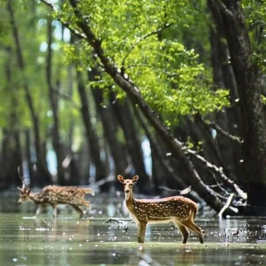
- Mammals: The iconic Bengal Tiger (Panthera tigris) reigns supreme as the apex predator. The Sundarbans is one of the last strongholds for this magnificent creature, uniquely adapted to swimming and hunting in the mangroves. Other mammals include fishing cats, jungle cats, leopard cats, spotted deer (chital), wild boar, rhesus macaques, and various species of otters and civets.
- Birds: A birdwatcher’s paradise, the Sundarbans is home to over 290 species of birds. It serves as a crucial wintering ground for migratory waterbirds and boasts a rich avifauna including kingfishers, eagles, storks, herons, and the critically endangered masked finfoot and spoon-billed sandpiper.
- Reptiles: Reptiles thrive in the warm, humid climate of the Sundarbans. Estuarine crocodiles, monitor lizards, various snakes (including cobras and kraits), and sea turtles (olive ridley, hawksbill) are prominent inhabitants.
- Amphibians: While less numerous than other groups, amphibians like frogs and toads also contribute to the biodiversity.
- Fish and Aquatic Life: The waterways teem with fish, crustaceans (crabs, shrimps), and mollusks. The Sundarbans is a critical nursery ground for many commercially important fish species, supporting livelihoods and food security. Irrawaddy dolphins and Gangetic dolphins are also found in the river systems.
This rich tapestry of wildlife makes the Sundarbans a globally significant biodiversity hotspot and a crucial area for conservation.
Endangered and Extinct Species – A Conservation Imperative
Despite its protected status, the Sundarbans faces significant biodiversity loss. The ecological quality of the forest has been declining, and several species have become locally extinct or are critically endangered.
- Extinct Species: Historically, the Sundarbans was home to species like the Javan rhinoceros, Indian rhinoceros, swamp deer (barasingha), hog deer, and water buffalo. These species have become locally extinct primarily due to hunting and habitat loss.
- Endangered Species: Numerous species currently inhabiting the Sundarbans are classified as endangered, including the Bengal tiger, estuarine crocodile, northern river terrapin, olive ridley sea turtle, Gangetic dolphin, masked finfoot, and spoon-billed sandpiper. Their continued survival depends on effective conservation measures.
The decline in populations of key mangrove species like sundari and gewa, coupled with the loss of wildlife, underscores the urgent need for intensified conservation efforts to protect the unique biodiversity of the Sundarbans for future generations.
Threats to the Sundarbans: Challenges and Conservation Imperative
The Sundarbans, despite its ecological significance and protected status, is facing a barrage of threats, both natural and human-induced. Understanding these threats is crucial to formulating effective conservation strategies.
Climate Change: Sea Level Rise and Salinity Intrusion – A Growing Crisis
Climate change poses an existential threat to the Sundarbans. Sea level rise is perhaps the most critical concern. The low-lying nature of the delta makes it exceptionally vulnerable to even small increases in sea level. Predictions suggest a significant rise by the end of the 21st century, which could inundate vast swathes of the Sundarbans, potentially destroying a large percentage of the mangrove forests.
Increased salinity is another major consequence of climate change. Reduced freshwater flow from upstream, coupled with sea level rise, leads to saltwater intrusion further inland. This increased salinity stresses mangrove species, particularly the sundari tree, which is sensitive to high salt concentrations. Changes in salinity can also disrupt the delicate balance of the ecosystem, impacting fish populations and other wildlife.
Natural Hazards: Cyclones and Storm Surges – The Fury of Nature
The Sundarbans lies in a region highly susceptible to cyclones and storm surges. These natural disasters are becoming more frequent and intense due to climate change. Cyclones like Sidr (2007) and Aila (2009) have caused widespread devastation in the Sundarbans, damaging mangrove forests, impacting wildlife, and devastating human settlements. The protective role of mangroves against storm surges is crucial for the millions of people living in the surrounding coastal areas. However, the mangroves themselves are vulnerable to extreme weather events, creating a vicious cycle of damage and vulnerability.
Human-Made Hazards: Rampal Power Plant, Oil Spills, and Deforestation – The Price of Development?
Human activities are exacerbating the threats to the Sundarbans.
- Rampal Power Plant: The proposed coal-fired Rampal power plant, situated just north of the Sundarbans in Bangladesh, has raised serious environmental concerns. Activists and UNESCO reports warn of potential damage from pollution, increased river traffic, and coal ash disposal, threatening the delicate ecosystem.
- Oil Spills: Accidental oil spills, like the 2014 Sela River oil tanker disaster, can have devastating impacts on the Sundarbans. Oil pollution contaminates water and soil, harming mangroves, fish, dolphins, and other wildlife. Long-term ecological damage can be significant.
- Deforestation and Habitat Conversion: While large-scale deforestation within the core Sundarbans is limited due to its protected status, surrounding areas are under pressure from agricultural expansion, aquaculture (shrimp farming), and human settlements. Conversion of mangrove forests and freshwater swamp forests to other land uses reduces habitat for wildlife and weakens the natural defenses against storms and sea-level rise.
Conservation Efforts and Sustainable Management: Charting a Path Forward
Despite the formidable challenges, there is hope for the Sundarbans. Conservation efforts are underway, and sustainable management practices are being explored to safeguard this invaluable ecosystem. Key strategies include:
- Mangrove Restoration and Afforestation: Planting mangroves in degraded areas and creating new mangrove forests can help restore habitat, strengthen coastal defenses, and sequester carbon.
- Protected Area Management: Effective management of existing protected areas (national parks, wildlife sanctuaries) is crucial, including stricter enforcement of anti-poaching measures and habitat protection.
- Community-Based Conservation: Engaging local communities in conservation efforts is essential. Providing alternative livelihoods, promoting sustainable resource use, and raising awareness about the value of the Sundarbans are vital for long-term success.
- Climate Change Adaptation: Developing strategies to adapt to the impacts of climate change is paramount. This includes exploring “managed retreat” from vulnerable areas, investing in resilient infrastructure, and promoting climate-smart agriculture and aquaculture practices.
- International Collaboration: Given that the Sundarbans is shared by India and Bangladesh, cross-border collaboration on conservation and management is essential.
The future of the Sundarbans hinges on a concerted global effort, involving governments, local communities, scientists, and conservation organizations, to address the threats and implement effective, sustainable solutions.
The Sundarbans Economy and Human Life: A Symbiotic Relationship
The Sundarbans is not just a wilderness; it is also home to millions of people who depend on its resources and are intrinsically linked to its health and well-being. Understanding the economic significance of the Sundarbans and the lives of the communities within and around it is essential for sustainable management.
Economic Significance: Forestry, Fishing, and Tourism – Pillars of the Local Economy
The Sundarbans plays a vital role in the economy of southwestern Bangladesh and parts of eastern India. Its economic contributions are multifaceted:
- Forestry: The Sundarbans is a major source of forest products, including timber, fuelwood, and pulpwood. Sundari wood is prized for construction and furniture making. Sustainable forestry practices are crucial to ensure long-term resource availability.
- Fishing and Aquaculture: The waterways of the Sundarbans support a thriving fishing industry, providing livelihoods for countless communities. Crustaceans (shrimp, crabs) and mollusks are also harvested. Aquaculture, particularly shrimp farming, is also practiced, but needs to be managed sustainably to avoid negative environmental impacts.
- Non-Timber Forest Products: Honey, beeswax, thatching materials, and medicinal plants are harvested from the Sundarbans, providing additional income sources for local communities.
- Tourism: Eco-tourism is a growing sector in the Sundarbans, attracting both domestic and international visitors. Wildlife viewing (especially tiger spotting), boat tours through the waterways, and experiencing the unique mangrove ecosystem are major draws. Responsible tourism can generate revenue and promote conservation awareness.
The Sundarbans ecosystem provides valuable ecological services that underpin the regional economy, including nutrient cycling, water purification, storm protection, and coastal stabilization.
Agriculture and Habitation in the Sundarbans: Living with the Tides
While large parts of the Sundarbans are uninhabited, there are pockets of human settlements and agricultural lands, particularly in areas shielded from direct tidal inflow. Agriculture in the Sundarbans is uniquely adapted to the seasonal flooding and saline conditions.
- Monsoon Agriculture: During the monsoon season, low-lying agricultural lands are flooded. Deepwater rice or floating rice is the primary crop, adapted to tolerate prolonged inundation.
- Dry Season Agriculture: In the dry winter season, lands near villages are irrigated from ponds filled during the monsoon, allowing for the cultivation of vegetable crops (Rabi crops).
- Aquaculture Integration: In some areas, farms and mangrove areas are being converted to aquaculture, highlighting the interplay between agriculture and fisheries.
Habitation in the Sundarbans is often characterized by a close relationship with the natural environment, with communities relying on boats for transport, fishing for sustenance, and adapting to the rhythm of the tides.
Administration and Community Involvement: Stewards of the Forest
The Sundarbans is jointly administered by Bangladesh and India. Both countries have established forest departments, protected areas, and implemented regulations to manage and conserve the ecosystem. Effective administration requires:
- Inter-Agency Coordination: Collaboration between forest departments, wildlife agencies, tourism authorities, and other government bodies is essential.
- Community Participation: Involving local communities in decision-making processes, conservation initiatives, and sustainable resource management is crucial for long-term success.
- Law Enforcement: Combating poaching, illegal logging, and encroachment requires robust law enforcement and monitoring.
- International Cooperation: Transboundary cooperation between India and Bangladesh is vital for managing the shared Sundarbans ecosystem.
Recognizing local communities as key stakeholders and empowering them to be stewards of the forest is increasingly seen as a cornerstone of effective conservation in the Sundarbans.
Exploring the Sundarbans: Tourism and Unforgettable Experiences
The Sundarbans offers a unique and unforgettable tourism experience, attracting nature enthusiasts, wildlife lovers, and adventure seekers from around the world. Eco-tourism, if managed responsibly, can be a powerful tool for conservation, generating revenue and raising awareness about the importance of this fragile ecosystem.
Key Attractions and Points of Interest: Wonders to Discover
The Sundarbans is brimming with attractions:
- Sundarbans National Park (India): A core protected area in the Indian Sundarbans, renowned for tiger sightings, diverse wildlife, and boat safaris through the waterways.
- UNESCO World Heritage Sites (Bangladesh): The three protected areas in the Bangladesh Sundarbans – Sundarbans West, South, and East – offer pristine mangrove forests, diverse wildlife, and opportunities for exploration.
- Sajnakhali Wildlife Sanctuary (India): Famous for its birdlife, watchtower, and mangrove interpretation center.
- Netidhopani (India): Historical ruins of a temple and scenic views.
- Katka (Bangladesh): A popular tourist destination in Bangladesh Sundarbans, known for its beach, tiger sightings, and wildlife.
- Hiron Point (Bangladesh): Another key wildlife viewing area in Bangladesh.
- Dublar Char (Bangladesh): A fishing island known for its dry fish production and a gathering point for Hindu pilgrims during Rash Mela.
Boat safaris through the intricate waterways are the primary way to explore the Sundarbans, offering opportunities for wildlife viewing, birdwatching, and immersing oneself in the unique mangrove landscape.
Embark on a Sundarban Adventure: Tour Packages and Festive Experiences
For those eager to immerse themselves in the wonders of this unique ecosystem, a variety of Sundarban tour packages are readily available, designed to suit diverse schedules and interests. Whether you’re looking for a quick Sundarban 1 day tour for a brief glimpse of the mangrove forests, a more in-depth Sundarban tour 1 night 2 days getaway, or a comprehensive Sundarban tour 2 night 3 days package to fully explore the region’s biodiversity, there are options for every traveler. Reputable sundarban travel agency services can expertly craft personalized itineraries, handle permits, arrange boat safaris, and secure accommodations. When planning your Sundarban tour, be sure to also search for variations in spelling like Sundarnban online to broaden your research. For a truly unique cultural experience, consider timing your visit with the Sundarban Ilish Utsav, a local festival celebrating the delicious Hilsa fish and the rich cultural heritage of the region, adding a festive dimension to your mangrove exploration.
Eco-Tourism and Responsible Travel: Tread Lightly, Appreciate Deeply
Eco-tourism in the Sundarbans should be guided by principles of sustainability and responsibility. This means:
- Minimize Environmental Impact: Choosing eco-friendly tour operators, respecting wildlife, and avoiding littering.
- Support Local Communities: Staying in locally owned accommodations, hiring local guides, and purchasing local products.
- Promote Conservation Awareness: Learning about the Sundarbans ecosystem, the threats it faces, and supporting conservation initiatives.
- Respect Cultural Sensitivities: Being mindful of local customs and traditions.
Responsible eco-tourism can be a win-win, benefiting both the environment and local communities while providing visitors with enriching and authentic experiences.
Planning Your Visit: Best Time and How to Get There
- Best Time to Visit: The dry season (October to April) is generally considered the best time to visit the Sundarbans, with pleasant weather and better wildlife viewing opportunities. The monsoon season (June to September) can be challenging due to heavy rainfall and potential cyclones.
- How to Get There: Access to the Sundarbans is primarily by boat. Entry points in India include Canning Town and Godkhali in West Bengal. In Bangladesh, major entry points are Mongla and Khulna. Getting to these entry points involves a combination of train, bus, and sometimes ferry travel from major cities like Kolkata (India) and Dhaka (Bangladesh).
Planning a trip to the Sundarbans requires careful consideration of permits, transportation, accommodation (often boat-based or eco-lodges), and responsible tour operators. However, the rewards of exploring this extraordinary ecosystem are immeasurable.
Conclusion: The Future of the Sundarbans – A Shared Responsibility
The Sundarbans, the world’s largest mangrove forest, is a global treasure. Its ecological significance, biodiversity richness, and cultural heritage are undeniable. However, this precious ecosystem stands at a crossroads. The threats it faces – climate change, natural disasters, and human-induced pressures – are formidable and growing.
Re-emphasizing the Importance of Conservation: A Priceless Legacy
The conservation of the Sundarbans is not just a regional concern; it is a global imperative. Protecting this ecosystem is vital for:
- Biodiversity Preservation: Safeguarding the rich array of flora and fauna, including iconic and endangered species like the Bengal tiger.
- Climate Change Mitigation and Adaptation: Mangrove forests are powerful carbon sinks, helping to mitigate climate change. They also provide crucial coastal protection against storms and sea-level rise, serving as a natural buffer for millions of people.
- Livelihoods and Economic Security: Sustainable management of the Sundarbans is essential for supporting the livelihoods of local communities who depend on its resources.
- Ecological Services: Maintaining the vital ecological functions of the Sundarbans, including water purification, nutrient cycling, and nursery grounds for fisheries.
Call to Action for Protection and Sustainability: A Collective Effort
The future of the Sundarbans depends on collective action. We must:
- Strengthen Conservation Policies and Enforcement: Governments need to implement and enforce robust conservation policies, including stricter protection of mangrove forests and wildlife.
- Promote Sustainable Development: Balancing development needs with environmental protection, ensuring that economic activities are ecologically sustainable.
- Invest in Research and Monitoring: Continued scientific research and monitoring are crucial to understand the dynamics of the Sundarbans ecosystem and the impacts of climate change and human activities.
- Raise Public Awareness: Educating the public about the value of the Sundarbans and the threats it faces is essential to build support for conservation.
- Support Local Communities: Empowering local communities to be active participants in conservation and sustainable management is key to long-term success.
- Global Collaboration: International cooperation between India and Bangladesh, and support from global organizations, are vital to address the transboundary challenges facing the Sundarbans.
The Sundarbans is a living legacy, a testament to the power and beauty of nature. It is our shared responsibility to protect this extraordinary ecosystem, ensuring its survival for generations to come. Let us heed the call to action and work together to safeguard the enchanting Sundarbans, a jewel of our planet.