I. Sundarbans – How It Originated
It is said that two to three million years ago, the Sundarbans was submerged under the sea. It is believed that before the sixth century, the delta of the Sundarbans was fully formed due to the massive deposition of silt by the slow-flowing rivers Ganga, Brahmaputra, and Meghna at the narrow sea interface of the region.
However, the most widely accepted belief is that a series of tectonic movements caused elevations and depressions in the area. This, coupled with the deposition of alluvial silt brought by the major river systems Ganga-Brahmaputra-Meghna, led to the formation of the Lower Gangetic Delta, now known as the Sundarbans.
On the other hand, physiographical studies suggest that tidal waves and numerous estuaries pushed back silt from the Bay of Bengal into dead or moribund channels, gradually raising the riverbeds and resulting in the formation of islands.
II. How the Name ‘Sundarbans’ Was Derived
There are several theories regarding the origin of the name Sundarbans:
- From the ‘Sundari’ tree: The most accepted theory suggests that the name comes from the Sundari (Heritiera fomes) tree, which is abundant in the Sundarbans forests.
- From ‘Samundar-Bon’ (Sea Forest): Some believe the name is derived from the Bengali words ‘Samundar-Bon’, meaning ‘Forest near the Sea,’ as the region is located along the seashore and frequently affected by tidal waves.
- From the ‘Sundha’ River: Another theory suggests that the Sundarbans got its name from the Sundha River in the Barisal district. The forest on the bank of this river was once called ‘Sundhar-Bon,’ which later became ‘Sundarbans.’
III. Geographical Location of Sundarbans
The Sundarbans is located slightly south of the Tropic of Cancer, spanning across India and Bangladesh. The geographical coordinates are:
- Latitude: 21° 32’ N to 22° 40’ N
- Longitude: 88° 03’ E to 89° E
IV. History of Sundarbans
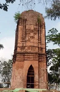
Since its creation, the Sundarbans Mangrove Forests, the largest in the world, have been under the rule of various foreign and local dynasties. Some of the most notable rulers include:
Ancient and Medieval Rulers:
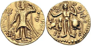
- Kushan Dynasty (c. 30 – c. 230 AD): Kujula Kadphises.
- Pala Dynasty (10th – 11th Century AD): The Kamboja-Pala rulers controlled parts of Bengal.
- Sen Dynasty (1096 – 1230 AD): Notable rulers included Bijoy Sen, Ballal Sen, Viswarup Sen, and Keshab Sen.
- Pathan Rule (1204 – 1339 AD) and Mughal Rule (1526 – 1857 AD):
- The first Mughal ruler Babur (1526 – 1530 AD) and the last Mughal ruler Bahadur Shah II (1837 – 1857 AD).
- Emperor Akbar (1582 AD) appointed Todor Mal as Revenue Minister.
- Prince Suja, son of Shah Jahan, divided the Sundarbans into Revenue Divisions (Parganas) such as Nimakmahal, Junglemahal, Paihati, Madanamalla, Sagar, etc.
- Baro Bhuiya (15th Century AD): Bikramaditya (Jessore) and his son Pratapaditya ruled the Sundarbans before it was attacked by Arakanese, Mug pirates, and Portuguese raiders.
- Portuguese Dynasty (1505 – 1961 AD): Portuguese pirates raided the Sundarbans before British rule.
British Rule (1612 – 1947 AD):
- East India Company Rule (1757 – 1858 AD):
- The British acquired the Sundarbans in 1828.
- First British survey (1829 AD) by Lt. Hodges.
- The Sundarbans was divided into ‘Lots’ and leased out to Zamindars for reclamation, deforestation, and cultivation (completed in 1868).
- In 1878, the entire forest was declared a Reserve Forest, and in 1879, the Sundarbans came under the control of the Forest Department.
- M.U. Green was appointed as the first forest officer of the Sundarbans.
V. History of 24-Parganas
After the Battle of Plassey (20th December 1757) and as per Condition No. 4 of the agreement between Mir Jafar and the East India Company, the 24 ‘Jungle Mahals’ or ‘Parganas’ were gifted to Lord Clive of the East India Company. These areas extended up to Kulpi in the south, including Kolkata.
List of 24 Parganas during British Rule:
- Akbarpur
- Amirpur
- Azimabad
- Balia
- Kolkata
- Medanmalla
- Magura
- Paikhan
- Ikhtiarpur
- Baridhati
- Dakkhin Sagar
- Khaspur
- Shahanagar
- Hatiagarh
- Panchkuli
- Mayda
- Santal
- Muragacha
- Uttar Pargana
- Sahapur
- Kharijuri
- Manpur
- Basandheyab
- Garh
Current Administrative Status:
The names of these Parganas are no longer in use. Over time, these areas have been renamed and/or subdivided for modern civil administration.
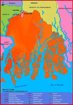
Present-Day Sundarbans in India & Bangladesh:
The Sundarbans today is divided between India and Bangladesh, covering a vast network of rivers, estuaries, and dense mangrove forests.
Conclusion
The Sundarbans is a unique and ecologically rich region shaped by natural forces and historical events. Over centuries, it has been influenced by rulers from different dynasties, colonial powers, and modern conservation efforts. Despite challenges like deforestation, climate change, and rising sea levels, the Sundarbans continues to be a vital natural habitat and a protective barrier for the coastal regions of India and Bangladesh.
সুন্দরবন: উৎপত্তি, নামকরণ, ভূগোল ও ইতিহাস
সুন্দরবনের উৎপত্তি
ধারণা করা হয় যে দুই থেকে তিন মিলিয়ন বছর আগে সুন্দরবন সমুদ্রের নিচে ছিল। ষষ্ঠ শতকের আগেই গঙ্গা, ব্রহ্মপুত্র ও মেঘনা নদীর ধীর প্রবাহের ফলে বিশাল পরিমাণ পলির সঞ্চয় হয়ে সুন্দরবনের ডেল্টা গঠিত হয়।
তবে সবচেয়ে প্রচলিত ধারণা অনুযায়ী, একাধিক ভূতাত্ত্বিক গতিবিধির ফলে এই অঞ্চলে উচ্চতা ও নিম্নতা তৈরি হয়, পাশাপাশি নদীগুলোর দ্বারা বহন করা পলি জমে সুন্দরবনের নিম্ন গঙ্গা বদ্বীপ গঠিত হয়।
অপরদিকে, ভূতাত্ত্বিক গবেষণায় দেখা যায় যে, জোয়ার-ভাটার কারণে বঙ্গোপসাগর থেকে পলি ফিরে আসে এবং এটি মৃত বা মরীচিকা চ্যানেলগুলোর মধ্যে প্রবাহিত হয়ে ক্রমশ নদীর তলদেশ উঁচু করে দ্বীপ গঠনের কারণ হয়।
সুন্দরবনের নামকরণ
অনেকের মতে, ‘সুন্দরবন’ নামটি ‘সুন্দরী’ গাছ থেকে এসেছে, যা এই অরণ্যের অন্যতম প্রধান বৃক্ষ।
অনেকে মনে করেন, নামটি এসেছে ‘সমুদ্র-বন’ থেকে, কারণ এই বন সমুদ্র উপকূলে অবস্থিত এবং সমুদ্রের জোয়ারের জল এ অঞ্চলের মাটিকে আর্দ্র রাখে।
আরেকটি প্রচলিত ধারণা অনুযায়ী, বাংলাদেশের বরিশাল জেলার ‘সুন্ধা’ নদীর তীরে অবস্থিত বন থেকে ‘সুন্ধার বন’ নামের উৎপত্তি, যা পরে সুন্দরবন নামে পরিচিত হয়।
সুন্দরবনের ভৌগোলিক অবস্থান
সুন্দরবন ভারত ও বাংলাদেশের উপকূলীয় অঞ্চলে, কর্কটক্রান্তির ঠিক দক্ষিণে অবস্থিত। এর ভৌগোলিক অবস্থান:
- অক্ষাংশ: ২১° ৩২ মিনিট থেকে ২২° ৪০ মিনিট উত্তর
- দ্রাঘিমাংশ: ৮৮° ০৩ মিনিট থেকে ৮৯° পূর্ব
সুন্দরবনের ইতিহাস
সুন্দরবন ও এর অরণ্য তৈরি হওয়ার পর এটি বহু শাসকের অধীনে ছিল, যাদের মধ্যে উল্লেখযোগ্য কয়েকজন হলেন:
- কুষাণ সাম্রাজ্য: কুজুলা কাদফিসেস (খ্রিস্টপূর্ব ৩০ – খ্রিস্টপূর্ব ২৩০)
- পাল রাজবংশ: নবম থেকে একাদশ শতাব্দীতে বাংলা শাসন করেছিল।
- সেন রাজবংশ: বিজয় সেন (১০৯৬ – ১১৫৯), বল্লাল সেন (১১৫৬ – ১১৭৯), কেশব সেন (১২২৫ – ১২৩০)।
- পাঠান ও মোগল শাসন (১২০৪ – ১৮৫৭): মোগল সম্রাট আকবর ১৫৮২ সালে সুন্দরবনের রাজস্ব আদায়ের জন্য টোডরমলকে দায়িত্ব দেন। পরবর্তীকালে শাহজাহানের পুত্র শাহ সুজা সুন্দরবনের অঞ্চলগুলিকে একাধিক পরগনায় বিভক্ত করেন।
- বারো ভুঁইয়া: বিক্রমাদিত্য (যশোর) ও তার পুত্র প্রতাপাদিত্য ১৫ শতকে সুন্দরবন শাসন করতেন। পরবর্তীকালে আরাকান, মগ ও পর্তুগিজ জলদস্যুরা সুন্দরবনের বিশাল ক্ষতি সাধন করে।
- পর্তুগিজ শাসন (১৫০৫ – ১৯৬১): পর্তুগিজ জলদস্যুরা এই অঞ্চলে ব্যাপক লুটতরাজ চালিয়েছিল।
- ব্রিটিশ শাসন (১৬১২ – ১৯৪৭): ১৭৫৭ সালে প্লাসির যুদ্ধের পর ব্রিটিশরা সুন্দরবনের নিয়ন্ত্রণ নেয়। ১৮২৮ সালে তারা সুন্দরবন অধিগ্রহণ করে এবং ১৮২৯ সালে লেফটেন্যান্ট হজেস দ্বারা প্রথমবারের মতো সুন্দরবনের জরিপ করা হয়। ১৮৭৮ সালে সুন্দরবনের বনভূমি সংরক্ষিত বন হিসেবে ঘোষণা করা হয় এবং ১৮৭৯ সালে বন বিভাগের অধীনে আসে। সুন্দরবনের প্রথম বন আধিকারিক ছিলেন এম. ইউ. গ্রিন।
২৪ পরগনার ইতিহাস
১৭৫৭ সালের ২০ ডিসেম্বর সিরাজউদ্দৌলার পরাজয়ের পর, ইস্ট ইন্ডিয়া কোম্পানির সঙ্গে মীরজাফরের চুক্তি অনুযায়ী, কলকাতাসহ দক্ষিণে কুলপি পর্যন্ত বিস্তৃত ২৪টি ‘জঙ্গল মহাল’ বা পরগনা লর্ড ক্লাইভকে উপহার দেওয়া হয়।
ব্রিটিশ শাসনকালে ২৪ পরগনার নাম ছিল:
১) আকবরপুর
২) আমিরপুর
৩) আজিমাবাদ
৪) বালিয়া
৫) কলকাতা
৬) মেদনমল্লা
৭) মাগুরা
৮) পাইখান
৯) ইখতিয়ারপুর
১০) বারিধাতি
১১) দক্ষিণ সাগর
১২) খাসপুর
১৩) শাহানগর
১৪) হাতিয়াগড়
১৫) পাঁচকুলি
১৬) মাইদা
১৭) সান্তাল
১৮) মুরগাছা
১৯) উত্তর পরগনা
২০) সাহাপুর
২১) খারিজুরি
২২) মানপুর
২৩) বসন্দেয়াব
২৪) গড়
বর্তমানে এই পরগনাগুলোর নাম পরিবর্তন করা হয়েছে এবং প্রশাসনিক সুবিধার জন্য ছোট ছোট অঞ্চলে বিভক্ত করা হয়েছে।
ভারত ও বাংলাদেশের সুন্দরবন অঞ্চলের বর্তমান কাঠামো
সুন্দরবন বর্তমানে ভারত ও বাংলাদেশের মধ্যে বিভক্ত। ভারতের পশ্চিমবঙ্গ রাজ্যে সুন্দরবনের বড় অংশ রয়েছে, যেখানে এটি মূলত দক্ষিণ ২৪ পরগনা ও উত্তর ২৪ পরগনা জেলায় বিস্তৃত। বাংলাদেশের খুলনা, সাতক্ষীরা ও বাগেরহাট জেলায় সুন্দরবনের প্রধান অংশ রয়েছে।
সুন্দরবন তার অনন্য জীববৈচিত্র্য, প্রাকৃতিক সৌন্দর্য এবং বৈশ্বিক পরিবেশগত গুরুত্বের জন্য ইউনেস্কো বিশ্ব ঐতিহ্যবাহী স্থান হিসেবে স্বীকৃত হয়েছে। এটি শুধুমাত্র ভারতের নয়, সমগ্র বিশ্বের একটি মূল্যবান সম্পদ।